


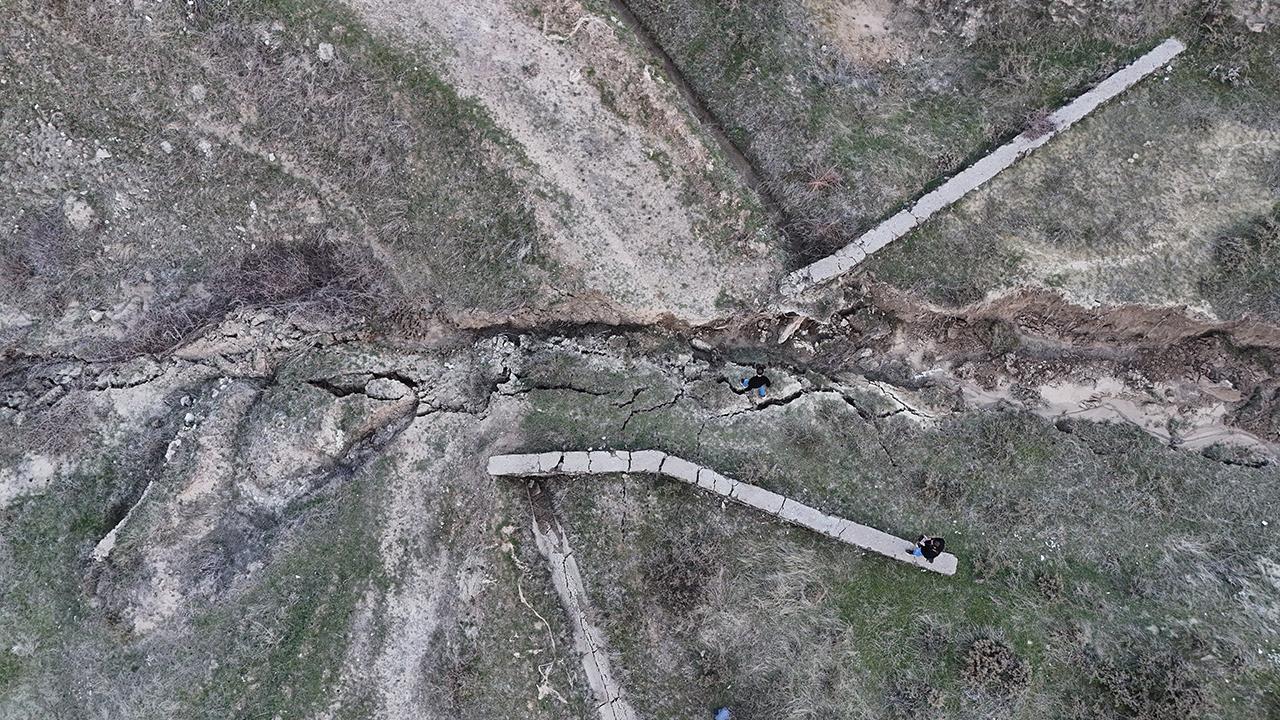
A 4.7 magnitude earthquake centered in Elazığ’s center on March 30, with a depth of 13.83 kilometers, was also felt in the village of Bahçeli, connected to the center of Bingöl. Following the earthquake, the residents of Bahçeli realized that the water supply in the evacuation depot had been cut off. The village headman, Sıtkı Karakoç, along with some villagers, inspected a water canal located about 2.5 kilometers from the village. They noticed significant displacement in the canal, burst pipes, landslides on the part of the land facing the stream, and various cracks at different depths.
After the situation was reported, Dr. Kenan Akbayram, the Director of the Energy, Environment, Natural Disaster Implementation and Research Center at Bingöl University (BU), conducted an examination in the region and made some observations. Akbayram stated that there were displacements of up to 4 meters in the water canal and mentioned that the area was a large landslide field. He attributed the triggering of this landslide to the earthquake in Elazığ, saying that the canals had moved downward due to the vertical movement triggered by a fault and the influence of gravity. He emphasized that such landslides could occur at any time in Bingöl and even older landslides could be reactivated.
Akbayram also mentioned that there were many falling rocks in the area where the landslide occurred, which they considered normal. He explained that surfaces that could not hold themselves could move in this way during severe rain or snow melt events and earthquakes. Akbayram suggested that the main reason for the scenario in Bahçeli village was the earthquake. He pointed out the presence of several faults, including the Genc Fault Zone, in the region as well as the parallel faults to the East Anatolian Fault Zone. He stressed the importance of detailed research on these faults to determine the potential danger they pose to the region.
The village headman, Sıtkı Karakoç, also confirmed the findings about the water canal, stating that they had noticed the displacement during their inspection. Karakoç reported that there were burst and disconnected points in the drinking water canal and although repairs were made, water flow could not be restored. He described areas of bending and blockage in the canal due to shifting and the need to remove the hose from the surface due to the movement. Karakoç witnessed significant shifting and cracks in the water canal across the field.
The situation in Bahçeli village highlighted the potential risks of geologically active areas and the need for continuous monitoring and evaluation of faults to prevent further damage in the event of natural disasters. It also served as a reminder of the importance of taking proactive measures to strengthen infrastructure and ensure the safety of residents in earthquake-prone regions. The collaboration between local authorities, research institutions, and community members in identifying and addressing potential risks is crucial in mitigating the impact of natural disasters. The findings in Bahçeli village underscore the need for ongoing research and assessment of seismic activity to improve preparedness and response strategies in at-risk areas.


