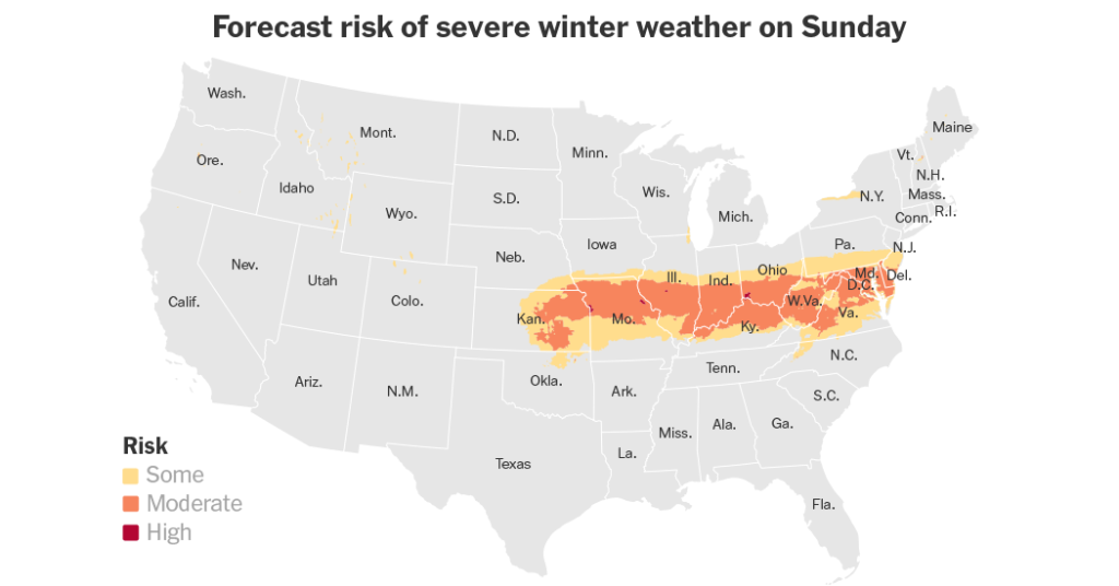
A powerful storm moved through the Mid-Atlantic States, bringing sleet, snow, and freezing rain that were expected to cause significant disruptions to travel and daily life on Sunday. Roads were glazed in ice in Kansas and Missouri, leading to closures of highways and airports. Over 30,000 customers were without power in Illinois, Kentucky, and Missouri. Several states declared states of emergency ahead of the storm, aiming to improve their responses to the weather system. The storm coincided with Arctic air sweeping into the United States, leading to brutally cold conditions.
Washington D.C. Mayor Muriel Bowser declared a snow emergency ahead of the storm, with forecasts predicting wind gusts exceeding 40 miles per hour and snowfall surpassing 15 inches. Blizzard warnings were issued for areas in Kansas, Missouri, and Nebraska, with predictions of the heaviest snowfall in a decade in some spots. Interstate 70 in northern Kansas was closed due to treacherous conditions, with vehicles struggling to navigate icy roads. Residents in Kansas City hunkered down as blizzard conditions swept the area, making roads and sidewalks impassable.
The storm system was expected to move into the Mid-Atlantic region, bringing heavy snowfall and icy conditions. Southern Illinois and Indiana were expected to see sleet and freezing rain, while areas between northeast Missouri and the central Appalachian Mountains were forecasted to receive heavy snow. The Weather Prediction Center warned that some regions could experience ice accumulations exceeding half an inch. By Monday morning, snow was forecast to fall across the Mid-Atlantic region, with Baltimore and Washington D.C. expected to receive several inches of snow.
The storm was described as one of the toughest seen in years, with a record amount of snowfall predicted within a short period of time. Businesses across the Midwest closed early in preparation for the storm, which was expected to bring severe weather conditions. Multiple flight cancellations were reported at airports across the region due to ice accumulation and hazardous conditions on the runways. By Tuesday, the snow was expected to taper off in the Mid-Atlantic, with cold and gusty weather forecasted for the remainder of the week. Temperatures were expected to be well below seasonal averages across the eastern part of the country.
Overall, the storm brought a mix of wintry precipitation and icy conditions across several states, leading to closures of highways, airports, and power outages. Severe weather warnings were in place for much of the region, with the potential for heavy snowfall and dangerous conditions. The storm represented a significant weather event that required emergency declarations and preparations in various states. Residents and authorities were advised to exercise caution and prepare for sustained cold temperatures following the storm’s passage.


