


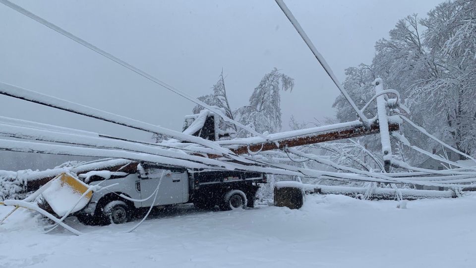
A late-season nor’easter brought heavy snow and strong winds to Maine and New Hampshire, leaving more than 400,000 homes and businesses without power. The widespread outages have left many without indoor heating as the storm blankets the region with snow, toppling trees and power lines. Snow accumulations in New England have exceeded a foot, with some areas seeing up to 24 inches of snow in less than three days. Although the heaviest snow has ended, several more inches of snow and gusty winds are expected, keeping the states under a winter weather advisory until early Friday morning.
The storm has made many roads impassable with debris and downed power lines blocking roadways, particularly in York County, Maine. State and local governments have shut down offices and schools ahead of the severe weather, with some districts opting for remote learning or canceling classes altogether. Hundreds of schools and government offices in New Hampshire also announced closures or remote classes due to the storm. First responders in East Kingston, New Hampshire reported a tree falling on a mobile home, leaving the structure a total loss.
Utility customers in Maine and New Hampshire continue to face power outages, with more than 289,000 customers in Maine and over 121,000 residents in New Hampshire without power early Friday. Winter storm warnings and advisories have been extended for parts of New England through Friday morning, with heavy snowfall and strong winds expected to continue. A different storm crossing the western US is bringing gusty winds, low-elevation rain, and high-elevation snow to the region before moving to the central US.
Parts of the Central Plains and Ohio River Valley are under freeze and frost alerts, with frost and freeze conditions expected to kill crops and vegetation and possibly damage outdoor plumbing. Freeze warnings are in effect for eastern Missouri, while frost advisories are in place for southeast Kansas, southwest Missouri, and north-central Arkansas. A freeze watch is also in effect for parts of southern Indiana, southwestern Ohio, and central Kentucky. High winds in the High Plains are creating critical fire danger as dry conditions and an ongoing drought increase the risk of wildfires.
An estimated 11 million people are under red flag warnings and fire weather watches across the Southern and Central High Plains as winds of over 25 mph combine with very dry conditions and low humidity. The threat zone includes western Texas, portions of the Texas panhandle, central and northern New Mexico, west Kansas, and eastern Colorado. Denver, Amarillo, and Roswell are among the cities at risk of fire-conducive weather. The worst conditions are expected in eastern Colorado, with sustained winds exceeding 30 mph and conditions favorable for rapid fire spread. To stay updated on the latest news and newsletters, individuals can create an account at CNN.com.


