


The central U.S. is facing a potentially dangerous severe weather event at the end of the weekend, with the possibility of a derecho hitting Kansas and Oklahoma with wind gusts over 100 mph and baseball-sized hail. This follows a deadly derecho in Texas and Louisiana that resulted in seven deaths and widespread power outages. The severe weather threat is expected to impact millions of people across the Plains and Midwest through at least Tuesday.
The National Oceanic and Atmospheric Administration’s Storm Prediction Center has increased the severity of the threat for Sunday, focusing on central Kansas as the area with the highest risk of destructive wind gusts and large hail. This threat is expected to move eastward on Monday and Tuesday, putting tens of millions of people in the Plains and Midwest at risk of extreme weather conditions, including damaging winds and tornadoes.
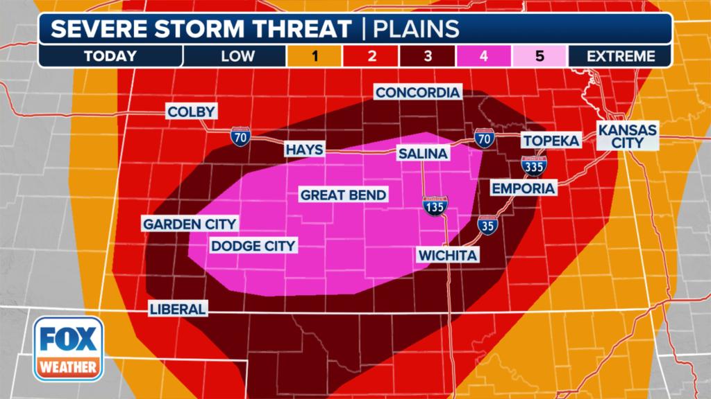
Severe thunderstorms are forecasted to develop in Kansas and Oklahoma late on Sunday afternoon, potentially leading to a derecho with wind gusts ranging from 80-100 mph, and possibly exceeding 100 mph. Parts of Kansas are at a Level 4 or Level 3 risk on the severe thunderstorm scale, which includes cities like Dodge City, Great Bend, Hays, and Topeka. Lightning, tornadoes, damaging wind gusts, and large hail are all possible threats associated with these severe thunderstorms.
The severe weather threat extends beyond Kansas and northwestern Oklahoma, with potential impacts on Missouri and Nebraska as well. The risk of damaging wind gusts and baseball-sized hail is of particular concern, despite the possibility of tornadoes in the region. Forecasters are closely monitoring the development of supercell thunderstorms that could form into a bow echo as they move across the area, bringing the risk of damaging winds comparable to those seen in hurricanes.
The thunderstorms expected on Sunday have the potential to produce wind gusts as strong as a Category 2 hurricane, with swaths of wind speeds between 80-100 mph and localized areas experiencing gusts higher than 100 mph. The threat of destructive winds, large hail, and other severe weather conditions poses a significant risk to residents in the affected areas, warranting caution and preparation for potentially hazardous weather. NOAA’s Storm Prediction Center continues to monitor the situation and provide updates on the evolving severe weather threat in the central U.S. throughout the weekend and into the upcoming workweek.


